Friday, July 31, 2009

Just Another Dog Day

DAY TWO HUNDRED AND TWELVE

When I get ready to go hiking Kahlua gets so excited because she always thinks she's going. Unfortunately, that is not always the case and she gets so depressed when I leave home without her.

This is the look I got yesterday when I left to go to Mount San Gorgonio.

So today I had no choice but to head to the Kahlua Trail.

My plan to create a trail by just walking is not coming together quite yet and I may have to resort to real trail building tools, like shovels and picks. One reason is that Kahlua can never follow the same path twice in a row. She likes to wander.

She also likes to sniff around and chase lizards, birds and bugs.

Instead of going across the hillside we head down a wash. I'll have to remember this way when I bring some of the kids because they love climbing down the boulders in the wash.

It looks like someone likes it so much they were camping here.

Looks like they probably left for the summer but no doubt those snowbirds will be back.

I sure hope Kahlua doesn't get too bored going to the same place all the time. It's going to take a bit of work before there's an actual trail here and there aren't a lot of places to go in the morning that offer the shade needed to hike in the desert summer. Hope that I hit the Lotto so we can get a cabin in the mountains for summer.

Thursday, July 30, 2009

Mount San Gorgonio: Top of Southern California

DAY TWO HUNDRED AND ELEVEN

Today I went and climbed Mount San Gorgonio. It's the tallest peak in Southern California at 11,502 feet and can be seen from over a hundred miles away. A lot of people refer to this peak as Big Bear but Big Bear is a lake and a city, not a mountain. It is not the prettiest mountain; it's basically a big mound of rock and dirt but since it is the tallest it is a destination for the hiker and mountaineer.


There are several ways up San Gorgonio but my favorite, the Vivian Creek Trail is closed right now due to some problem bears. I don't mind bears--I've hiked in Yosemite--but some people get a little freaked out by it so I did the South Fork Trail instead.


The trail winds through the conifers before climbing up to the barren summit of San Gorgonio. I hate the switchbacks on this trail. They are never ending, they are not steep enough and half of the time you are hiking in the wrong direction. I think when the made them they were looking to put people to work so they figured the more miles the better. It gets irritating after a while, though.


I come to a junction where the trail goes to either Dry Lake or Dollar Lake. I go up the Dry Lake side and will come down the Dollar Lake Trail.


I wonder why the call this Dry Lake.


After leaving Dry Lake you get to a place where the trail switchbacks up the bare rocky slopes of the mountain. It seems to take forever.


I am tempted to leave the trail and just scramble up this chute. I decide to stick to the trail because I told myself I wasn't going to rush today and I was just going to enjoy the mountain. I've climbed this chute in winter before and know it goes straight to the top.


When I climbed in winter, we were very careful about the snow conditions. Looking down you can see where an avalanche ripped out a large stand of big trees.


Along the trail you come across this wreckage of an old plane.


This plaque commemorates the men who lost their lives in this crash. This plaque was not here the last time I did this hike and I am glad it is here now. It reminds us that this is a solemn spot where men whose job was protecting our country lost their lives here. Rather than just some old wreckage knowing what happened here brings a moment of reflection and thoughts of those now putting their lives at peril to protect our freedom.


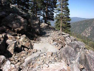
The trail continues on and I've had enough of these switchbacks.


After the switchbacks, the trail takes a LONG traverse of the entire mountain. Why they built the trail that way I have no idea. It's long and boring so I decide to just go straight up here.


From the top of the chute it's just a short but steep climb to the summit. If I stayed on the trail it'd take me about 1/2 hour longer.


When I get to the top, there's a regular party going on there. A day I've seen five people but at the summit there are at least thirty. It turns out that this is part of a group from a UCLA charity program. For eight days, inner city kids go to camp and as part of that they spend four days in the wilderness.


The summit register is stuffed. Loads of people climb this peak although a lot of them do it as an overnight adventure.


From the top you get a good view of Big Bear LAKE.


In addition to the UCLA group, there are lots of these little critters on the top. So many people enjoy their lunch here that there are lots of crumbs for them.


I head off in the opposite direction from which I came. I hope to get a nice view of the Southland but it's too hazy and the marine layer is thick today so no luck.


While the sign says Dollar Lake, I actually won't be going there today. It's off the main trail so I'll have to save that for another hike.


I bypass a shortcut down the face of the mountain and head down the Dollar Lake Trail.


I almost regret going this way because this trail is WAY rockier than the other way. My poor feet are not happy.


That is until we get to the Jeep. The first thing I do is thank them for taking me on a great adventure.

.

Wednesday, July 29, 2009

Summer Hours

DAY TWO HUNDRED AND TEN

This morning I went to the 1000 Palms Oasis for a little restful hike. It's a good thing I got there early.

For summer the place is only open for four hours a day. Of course, by ten o'clock it's too hot for most people to be hiking. Actually, by eight it's too hot for a lot of people. When I pull in the parking lot is completely empty.

The place is definitely being worked on. There are some fallen palms that have not been moved. Here's one that's collapsed right on this bench.

And this one is toppled upon this picnic table. With the oasis closing by ten no one will be staying for lunch anyway.

The oasis itself is quite overgrown and it looks like it's been a while since someone came this way with some loppers.

This walkway is even more overgrown. Who would've thought you could hike through a jungle in the desert?

You don't have to worry about that today. With the trails so overgrown going off them would be taking your life in your hands. Who knows what critters you might stumble upon?

Like this deadly creature! Look at the ears on that beast!

Don't think this could be dangerous? I've seen Monty Python and the Holy Grail. I know what these creatures can do. And I did not bring any Holy Hand Grenades.

I get over to the pond and it's closed and easy to see why. No temptation to ignore the No Swimming sign today.

On the way back I am not tempted to hike back to the oasis. That'll have to wait until fall. It's kinda creepy in there right now.

Tuesday, July 28, 2009

Resting Up

DAY TWO HUNDRED AND NINE

I've got a couple of longer adventures planned this coming week--20+ miles each--so I'll be doing a few shorter hikes in order to rest up. This morning I set the alarm for six in order to beat the heat. When I looked at the outside temperature and it was only 78º I thought maybe I can sleep a little longer. So I asked the wife to wake me in a half an hour. When she did I saw the temperature was only 84º so I dozed off again. I finally rolled out of the sack at around 7:30 and hit the trail around 8. It's still under 90º so I'm good.

Now the signs here in La Quinta can be confusing. This one says the Boo Hoff Trail is 7.5 miles and it's also a loop that's 12 miles. Or is the Boo Hoff 7.5 and the Lake Trail--whatever trail that is--4.5? Or is the Boo Hoff 7.5 and then loop ANOTHER 12? It's a good thing I don't really follow these signs or I'd be in trouble.

The soon to be Kahlua Trail is going to be along the base of this mountain but I'm too late to do it in the shade and besides Kahlua's at home. She likes sleeping in, too.

When the Kahlua Trail gets done, it'll be better than this. Do we really need two trails up this little saddle?

As I hike up to overlook the Quarry Golf Club, there are a few trail monuments and rock piles which may be graves. I have been told that these large circular rock piles once held ollas and were water caches for the Indians. It makes sense because this was a main thoroughfare for the Indians and there wasn't a lot of water around certain times of the year (like now).

Here's a bit larger of a hole and hollow rock mound.

Here's the overlook to the Quarry and my turnaround point. I don't want to aggravate a little shin splint that's starting to flare up. Of course there's not a sign to tell me how far I've come but even if there were I still wouldn't know.

On the way back I follow a line of rock piles but never find a real discernible trail.

That is, until this one. I get done at about 9:30 and it's still not bad, under 100º. And I still have time for a nap before work.

Monday, July 27, 2009

My Life Is Not My Own

DAY TWO HUNDRED AND EIGHT

Whenever I have a day off I get this illusionary idea that I am going to be able to go to the mountains and do some great hike in cool weather. I should know better. With the wife working I have babysitting duty and the boys would rather hang out with their friends watching endless reruns on Nickelodeon than do something wonderful and memorable with their dear old dad. Kids. Also, my wife made an appointment for me to draw some blood--don't even ask!--so I had to be home by three in the afternoon even if I had taken the kids away by parental force. So my dream of cool mountain air vanished in the intense glow of family responsibilities. It's not the first time.

Since I couldn't get to the cool mountain air as I'd hoped it was back to the heat. Since I wasn't traveling far, Kahlua insisted on coming along.

We went just south of The Quarry and were quickly into the wilderness.

The horse trail heads up to the ridge above this canyon but this is a better way for hikers to go even though I am a bit concerned about snakes in all these boulders.

Hiking uphill in the sand in 100º heat was not what I'd hoped for today but, hey, it's better than working.

You can see the sun shining on Rabbit Peak in the distance but we are completely in the shade. If not for that, we wouldn't last an hour out here.

We make a nice little loop using one of the many trails out here and head back to a cooler with iced beverages.

There are some little dens and small caves along the mountain side but we don't see anything in there at the moment. Any critters may have sensed us coming and gone into hiding.

The one animal we see are bats flittering across the sky. There are hundreds of them but since I don't have my good camera (that's another family story) so I can't get any good pictures of them but trust me, they're out there.

We get to the water faucets near The Quarry but they have turned them off for the night and I don't have a key to turn them back on.

But that's OK. I prepared for that. Kahlua enjoys some iced water in the cooler and dreams it's a cold mountain stream.