Showing posts with label Rancho Mirage Hiking. Show all posts

Sunday, December 20, 2009

Magnesia Falls Mine and Bighorn Sheep

THREE HUNDRED AND FIFTY FOUR

Magnesia Falls Canyon in Rancho Mirage is only open three months of the year, from October through December. It is really a shame because the canyon is a special place and spring is the best time to visit it.

Lots of people hike the canyon but I'm sure very few of them know there's a trail that leaves the canyon and heads up to a mining site. It's not a large mine, only some trenches and one pit short shaft about fifteen feet deep. I also think there's got to be a trail that leads to Cathedral City from the canyon. I haven't been able to follow it all the way but I know it's there. I'll find it yet.

After the hike in along a flood control ditch, you get to the fun stuff.

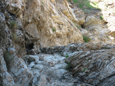
Climbing this big dry fall is much easier than it looks.

Someone has been up here and done a little work since I was here last. Either that or the rain just washed this clean and it looks new.

I hike up the canyon until I get to a big mesquite thicket. This is the site of Magnesia Spring. One thing I've learned from years of hiking in the desert is that where there is mesquite, there were sure to be have been Indians. It was a main food source for them.

I don't have to look far until I find some evidence of Indian activity.

With a little more exploration, I find a trail. I thought I saw this the last time I was in the canyon but it's nice to be sure.

I gain the ridge and see a couple of hikers in the canyon below.

The trail is mostly easy to follow but there are a few sections where I have to backtrack.

I notice from above some diggings in the earth and discover the mining area. I'd been here about twenty years ago but did not remember exactly how to get here.

I don't know what was mined up here but the earth has a different look to it.

There are several large trenches and this one vertical shaft about ten or fifteen feet deep.

I leave the mining area and start to head over in the direction of Cathedral City, hoping to find a distinct trail. What I find are several trails.

Some of which I'm sure were made by this guy.

He stands as if he is sizing me up for a while and then moves and crosses the slope below me.

He finds a good vantage point and stops again to check me out.

He's not really in a hurry to get anywhere which is good because it gives me time to get a few more pictures. One of these days I'm going to have to get a better camera, though.

It is amazing how well his body color matches that of the surrounding landscape. There have been times I have tried to point Bighorn out to groups of hikers where they couldn't be seen until they moved. They can be very well camouflaged.

I know some of the trails were made by the Bighorn but I doubt that they made this.

The trail I'm following, though, is heading more toward the Thunderbird Cove area in Rancho Mirage and not into Cathedral City as I'd hoped.

I'm going to have to do some more exploring in order to find the route that I want.

But it will have to be another day since the sun is already behind the hill and I've got a long way to go to get back and down the dry falls before dark.

Thankfully, I make it. Climbing up this fall during the day isn't too bad but I don't know how climbing down in the dark would be. I'm happy I don't have to find out.

Tuesday, October 20, 2009

Magnesia Spring Canyon

DAY TWO HUNDRED AND NINETY THREE

With Dead Indian Canyon open until the end of December I figured I'd go and try Magnesia Spring Canyon and hike up to Magnesia Falls if it, too, was open. It is.

This hike starts near the intersection of Mirage Road and Mirage Road in Rancho Mirage. Seriously.

The hike used to be nicer years ago when you could hike up from the top of Magnesia Falls Drive. Of course, you could also go in the spring when there was the possibility of water coming over the falls but those days are long gone. Now you walk up near a flood control ditch until you get to this sign with the rules of the canyon.

At the base of the first dry fall you get to climb is this little faux oasis. This was built to make a water guzzler seem more natural. It must be working because I saw more sheep droppings here than any other place I've been this year.

The second dry fall is about thirty feet tall but is not too difficult to climb. It looks intimidating at first glance but isn't that hard.

At the top of the fall is another guzzler which is a popular watering hole.

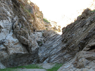
From the top of the fall you can look back at the interesting geology of the canyon wall. I've always thought this twisted wall of rock reminded me of a finger print.

There are lots of other little falls that make this a very fun canyon to hike in.

There a good size oasis on the left of the canyon and it's tempting to go left into this canyon but if you wait until the next oasis on the left that one will lead you to Magnesia Falls.

This is where you want to go left to get to Magnesia Falls. Sometimes there's water running down this section but it's doubtful there will be any before the end of the year.

This is Magnesia Falls. It is probably forty feet tall and is completely dry. During wet years this fall flows liberally and a pool forms at the bottom. This will be the end of today's hike but I plan to come back to this canyon several more times between now and January 1. There's another larger fall beyond this one, a mine and possibly an Indian Trail leading from Magnesia Spring so I have plenty of places to explore. There are also abundant side canyons that may be interesting. I only wish I could do it in the spring when the chance of finding water here is more probable.

Friday, March 27, 2009

Land Grab

DAY EIGHTY SIX

They're at it again. The land grabbers, I mean, managers have locked up yet another area in order to "protect the sheep". I just hate it when the public is locked off of public land. There's something about that that's just not right.

I headed over to Rancho Mirage to go to Magnesia Falls. I hiked here about a month ago but didn't climb the falls due to a sprained thumb and a lack of time. Well, the thumb is better and I have enough time this morning.

You cross this nice bridge to get to the "mountain park".

And then you have to cross this storm water catch basin in order to get to the canyon.

Unfortunately, you are met by this new sign that tells you the canyon is closed. I guess the person who put this sign here couldn't quite make it as a carpenter so they had to find themselves a government job.

This sign here tells you more about the closure. One of the things that peeves me about this whole land closure due to the sheep is that it is all based on pseudo-science. The biologists have not one bit of evidence that hikers impact the sheep. In fact, it has been noted for over 100 years, starting with George Wharton James in his monumental tome, The Wonders of the Colorado Desert, that sheep are unperturbed by human presence. There are a number of factors which have accounted for sheep's demise including being hit by cars, eating poisonous decorative plants, disease, mountain lion predation and being killed accidentally by biologists. Not once, to my knowledge, has a hiker ever been responsible for the death of a sheep. In fact, in Borrego Springs, they even keep count of all the sheep that are spotted by tourists hiking in Borrego Palm Canyon to no ill effect on the sheep. What's so different here?

Oh, I get it. It's a private party. You see, this land isn't closed to everyone. It's only closed to you and I. If you're "authorized" then it's OK to enjoy the canyon and the sheep. I guess sheep are only bothered by the unwashed cretins of the general public but not by the "experts" in the field. So if I spent seven years smoking weed in Humboldt while working on my four year degree, then it would be OK to hike here. I could be "authorized". But as it is, I'm unworthy.

I'm not going to let it bug me. I'll just go hike somewhere else today. Besides, if I go up there, the "experts" might come up and restrain me with a net and an attack helicopter like they do the Bighorn. I'm not ready to be collared and tracked.

So I decide to go over to South Palm Desert and ask the Visitor's Center if they have any maps on the new Wilderness areas just voted on by Congress, some of which are in our area. They don't. But they do have this fancy new stake with the number one on it. It must be from the stimulus money.

Now I see where the unclean hordes go who've been locked off other public land. I saw four large groups going on nature walks near the Visitor's Center. So much for solitude.

The flowers are dying out but at least I can appreciate the beauty of these cholla.

And this has got to be the biggest asparagus I have ever seen! Actually, that's the Desert Agave, Agave deserti. I wonder if you can make tequila out of them. I could use a shot or two right about now.

Oh Jeez! Yet another sign telling people where they can't go. When I hit two road blocks on the same day, it's time to head home.

I wish someone would explain to me why it is OK to deface the mountains and encroach on Bighorn habitat if you have untold millions of dollars but it is not OK for the public to enjoy the lands that they own.

On most days going hiking is a pure joy. There are a few days, however, where it can be frustrating. Today was just one of those days. Running into road blocks and closures is no fun when all you want to do is go out and commune with nature. People need places to get away from the everyday worries and find peace. It seems those places are getting tougher to find every day.

Thankfully, there are numerous other places to hike and find serenity. I just have to make sure I get to them before they close them off.

Monday, March 2, 2009

Milk of Magnesia

Day Sixty One

This week I will be taking it a bit easy since my hand is still swollen from my tumble on Saturday and I don't want to climb anything that I'm going to have to use my hands to get up or down. I still will be getting some mileage in, just not off-trail.


Today I went to the start of one of my favorite hikes in the desert. I don't know if that's saying much because I have about 40 favorite hikes but this is one of the first hikes I did when I moved here from Orange County about 25 years ago. The entrance to it has changed quite a bit but some things are unchanging. Magnesia Falls Canyon is one of them. It's still intriguing to me twenty-five years later.

Unlike when I first moved here and you entered the canyon from Magnesia Falls Drive, you now enter from Mirage Drive and the Blixeth Mountain Park. The park is adjacent to the oddly named Porcupine Creek Golf Club (to my knowledge there are no porcupines in the desert) that is part of the Blixeth estate. For more on the estate read here.

The "Mountain Park" has a trail that is suitable for your elderly parent or grandparent and their walker or wheelchair although there is currently no accessible parking.

There is this bench that looks like it was made by Fred Flintstone.

The trail then turns into a real trail.

But that trail is pretty much a dead end.

So after exploring the "Mountain Park", I set off toward Magnesia Falls.

You cross this big flood control basin

And on the other side you encounter no less than 13 signs stating that this is an ecological preserve. 13! I guess someone at Fish and Game has a family member in the sign making business and is getting a kick back or something.

You then get to the first fall which has the slightest trickle of water coming down it. I know there are native Palms in this canyon but I think these might have been planted here.

After surmounting this first little fall, you come to a larger dry fall which has a guzzler at the top for the Bighorn Sheep.

Here is a closer look at the Bighorn guzzler.

While I have climbed the entire length of the canyon before and really enjoy the Magnesia Falls Canyon to Art Smith Trail excursion, this is where I have to end my trip today. I will need two hands to do the rest of the hike and hopefully will be able to come back in a couple of weeks. Beyond this point there are two nice waterfalls and a mine, also, many native Palm trees.

When I go back in a few weeks I'll give advance notice so if anyone wants to go, you're welcome to come along. Hopefully, this will give you a little taste of what's up there.