Showing posts with label bedrock mortar. Show all posts

Sunday, December 20, 2009

Magnesia Falls Mine and Bighorn Sheep

THREE HUNDRED AND FIFTY FOUR

Magnesia Falls Canyon in Rancho Mirage is only open three months of the year, from October through December. It is really a shame because the canyon is a special place and spring is the best time to visit it.

Lots of people hike the canyon but I'm sure very few of them know there's a trail that leaves the canyon and heads up to a mining site. It's not a large mine, only some trenches and one pit short shaft about fifteen feet deep. I also think there's got to be a trail that leads to Cathedral City from the canyon. I haven't been able to follow it all the way but I know it's there. I'll find it yet.

After the hike in along a flood control ditch, you get to the fun stuff.

Climbing this big dry fall is much easier than it looks.

Someone has been up here and done a little work since I was here last. Either that or the rain just washed this clean and it looks new.

I hike up the canyon until I get to a big mesquite thicket. This is the site of Magnesia Spring. One thing I've learned from years of hiking in the desert is that where there is mesquite, there were sure to be have been Indians. It was a main food source for them.

I don't have to look far until I find some evidence of Indian activity.

With a little more exploration, I find a trail. I thought I saw this the last time I was in the canyon but it's nice to be sure.

I gain the ridge and see a couple of hikers in the canyon below.

The trail is mostly easy to follow but there are a few sections where I have to backtrack.

I notice from above some diggings in the earth and discover the mining area. I'd been here about twenty years ago but did not remember exactly how to get here.

I don't know what was mined up here but the earth has a different look to it.

There are several large trenches and this one vertical shaft about ten or fifteen feet deep.

I leave the mining area and start to head over in the direction of Cathedral City, hoping to find a distinct trail. What I find are several trails.

Some of which I'm sure were made by this guy.

He stands as if he is sizing me up for a while and then moves and crosses the slope below me.

He finds a good vantage point and stops again to check me out.

He's not really in a hurry to get anywhere which is good because it gives me time to get a few more pictures. One of these days I'm going to have to get a better camera, though.

It is amazing how well his body color matches that of the surrounding landscape. There have been times I have tried to point Bighorn out to groups of hikers where they couldn't be seen until they moved. They can be very well camouflaged.

I know some of the trails were made by the Bighorn but I doubt that they made this.

The trail I'm following, though, is heading more toward the Thunderbird Cove area in Rancho Mirage and not into Cathedral City as I'd hoped.

I'm going to have to do some more exploring in order to find the route that I want.

But it will have to be another day since the sun is already behind the hill and I've got a long way to go to get back and down the dry falls before dark.

Thankfully, I make it. Climbing up this fall during the day isn't too bad but I don't know how climbing down in the dark would be. I'm happy I don't have to find out.

Monday, December 14, 2009

Sheep Canyon, Santa Rosa Mountains

DAY THREE HUNDRED AND FORTY EIGHT

I went today to a place in the Santa Rosa Mountains south of Martinez Canyon that I'd never been to. I figured with a name like Sheep Canyon there was a good chance there might be Bighorn there or something else interesting.

To get to where I'd start hiking I'd have to drive through some orchards and a bit of a garbage dump. It's obvious that someone's been here before.

I head up the canyon looking to see if there might be a trail leaving the wash and heading up toward the hills.

I get past the mud cliffs and find an area to leave the wash and look around. The terrain is not easy to traverse. It's very rocky.

If you don't watch your every step there's a distinct possibility of falling and getting hurt. I get a bit injured and come inches from planting my face on a big boulder. Fortunately, my injuries are minor and I can continue on.

In the midst of a big boulder field, we come upon this nice barren flat.

It's readily obvious that this area has been visited before.

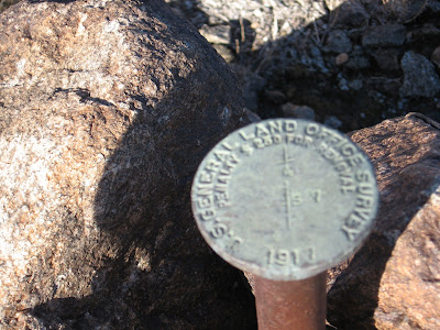
There's a benchmark from the General Land Office, a government agency that ceased to exist over 60 years ago. The date on it says 1917 and there's a good possibility it was put here then.

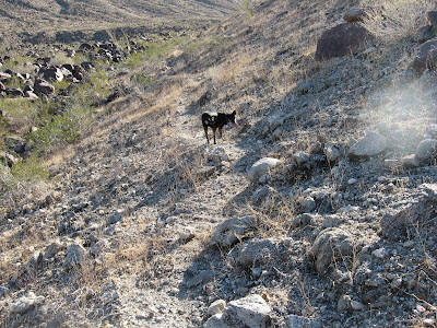
Looking south I see what I came here to find, a trail.

I'm sure there are dozens of trails in these mountains that no one knows about and I intend on finding them all.

The trail heads down to this wash but this is not the canyon I came here to explore today. It looks like there's possibly a palm oasis up there but that'll have to wait for another day.

We head over to Sheep Canyon to give it a little look.

The trail drops right into the canyon and I quickly see why.

The canyon is full of mesquite, a food staple of the Cahuilla Indians.

A bit further up the canyon is this weird looking rock area. It looks almost like concrete that has been weathered. There is lots of indications that Indians lived here.

There are several bedrock mortars all over the top of the rocks.

Some are over a foot deep.

On the south side of the wash is a little area that was obviously a campsite. There are a few fire rings and numerous mesquite bushes all around.

A few trails are up here as well.

It is obvious that someone's spent some time up here since the Indians moved on. I'd like to spend more time looking around but I also want to head up the canyon bit further and see if I can find another trail. I will be back, though.

The canyon has some very interesting geology.

More importantly, both to the wildlife in the area and the Indians back in the day, there's water. The water is flowing very well so there's a good chance that this is spring fed.

There are many sheep droppings near the water and it's evident that this must be a good place to spot either a sheep or other wildlife. At least, some biologists think so.

On the way back to the Jeep I make one more stop at the "concrete slab" to see how many more bedrock mortars I can find.

I count fourteen but there's a possibility there are more since there's some sand from the recent rains. When I come back--and I'm definitely coming back soon--I'm going to bring a little trowel to move some sand around and plan on spending more time. There's a great campsite so I might even plan a backpacking trip. This is one of my new favorite places.

Friday, February 13, 2009

Not Quite Capturing the Flag

Day Forty Four
Kids have more holidays now than I remember having when I was in school.  Today they are off for Lincoln's Birthday and Monday they are off for President's Day.  Wasn't the point of President's Day combining Lincoln's and Washington's Birthday into one holiday?  Maybe Friday the 13th is now a holiday so kids don't have anything bad happen to them in school.

I took my son, Nik, and two of his friends, Eliot and Tyler over by Lake Cahuilla to climb this little peak with a flag on top.

The gully directly below the flag looked a bit steep for the guys so I opted to take them up one a bit to the south.

The boys flew up that thing.  I kept expecting them to tire out and slow down but it never happened.  It must be nice to have young legs.  The guys reached the top about 30 seconds before I did.

Unfortunately, getting to the flag itself was not going to happen from where we were.  To get over there we'd have to climb over some sketchy class 4-5 crumbling rock.  Even if the boys wanted to--and they didn't--I wasn't going to let them go for it.  This is as close as we're getting today.

Looking down, you can see The Quarry Golf Club and Lake Cahuilla.  Even if we didn't get to the flag, the view was still breathtaking.

The fellas quickly learned that going up is a LOT easier than going down.  They scoot down on very loose dirt rocks until they get to some more stable, larger rocks below.

Woo Hoo!  It sure feels good to be on solid ground again!

After getting down, we head over to the Fish Traps, near the Torres Martinez Indian Reservation, because the boys have never been there.  Eliot and Nikolas find a little crevice in the rocks there.

A nice bedrock mortar in the area near the fish traps.

Looks like we caught three large corvina in one of the many traps along the hillside.

The boys hold some of the many pottery sherds found near the Fish Traps.  They wanted to bring them home but I told them to leave them for others to enjoy.  Besides, what good is a broken pot?  When we get home, they mention that they are glad we left them there.  They think it will be cool for someone else to see them and have the same experience they did.

Flowers are starting to bloom all over.  It's going to be a spectacular year in the desert for wildflowers.

We had a great time even though we didn't capture the flag this time.  But I'm looking forward to the next Friday the 13th holiday and I'm sure the boys are, too.