Friday, June 5, 2009

Biskra Palms

DAY ONE HUNDRED AND FIFTY SIX

The San Andreas Fault runs along the entire length of the north end of the Coachella Valley. In several sections the fault causes water to rise to the surface and in those place palm oases grow. There are several such oases on the southern section of the Indio Hills and today I hike to one of them, Biskra Palms.

You reach Biskra Palms from Washington Street by driving a series of rocky and sandy roads to the oasis. A truck or Jeep is required. You don't need 4WD but high clearance is essential to get there; the mini van ain't making it.

Biskra Palms is a thriving and healthy oasis with a lot of new growth.

It is easy to see why. There is a lot of water right at the surface. Looks tasty.

As I hike through the oasis I spy something interesting on the hill behind: a trail! I definitely have to go and check that out. I find a few other trails as I explore and ideas for more possible adventures.

I head up the hill to an area overlooking the gravel pit run by Granite Construction.

There's a lot of activity going on down there. This would be a good place to bring the boys because they just love construction equipment.

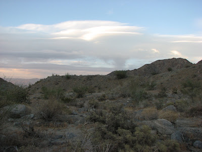
At the top of the trail is a fantastic view of the western Coachella Valley. I know where I'm coming next time I want to come and look at the sunset. If you click on the picture to enlarge it you'll see the Jeep WAY down there.

You also get a picture perfect view of the oasis itself and if you look real close on the right side of this picture you'll see another trail. I wonder where that one goes? Looks like I'll be coming back here to find out, doesn't it?

Thursday, June 4, 2009

A Light Workout

DAY ONE HUNDRED AND FIFTY FIVE

After yesterday's great hike I just did a nice little walk with the dog as my hike today. I'll put a couple of pictures of it up later. If you want you can go back and read yesterday's hike blog again. I'm still relishing the afterglow of how fun it was. Tomorrow I'll probably do another light and easy hike because Saturday I have another big, long adventure planned.

That oughta be a good one.

Here are the promised pictures.

Kahlua follows along. As much as that dog loves to go, I hate taking her when it's over 80º. Even though she's a desert dog I worry about her hiking in too much heat. That black coat doesn't help either.

Kahlua squeezes through rocks on the trail.

In the distance you can see where some idiot spray painted the rocks next to the trail. I'll have to remember to get some brown spray paint to cover it up next time I go to Walmart or Home Depot. I don't go to either of those places often so maybe I should write it down.

And when I get the paint I need to remember to get DARK brown.

Wednesday, June 3, 2009

Best Day on San Jacinto EVER!


DAY ONE HUNDRED AND FIFTY FOUR

San Jacinto is my favorite mountain. I've climbed it dozens of times from all directions and in all seasons. It never fails to disappoint and I never get tired of it. Of any mountain I've climbed--Whitney, Rainier, Hood, San Gorgonio to name a few--I think it has the best view. While it is easily accessible from the Palm Springs Aerial Tramway, there are also some very challenging routes up the mountain which involve the need for mountaineering skills and equipment. Anyone living in Southern California should climb it at least once.

Of all the great hikes I have ever had on Mount San Jacinto today's was probably the best.

I started from the Tram and hiked up to Sid Davis Canyon. This is the best way up the mountain and the quickest. The weather was overcast, a bit cool with just a hint of breeze. The temperature was about 50º at the Tram. Sid Davis Canyon starts where the Round Valley Trail crosses the creek. The trail is steep in points but it is MUCH shorter than the main Round Valley Trail. I go this way 90% of the time.

The trail comes out to Tamarack Valley just below Cornell Peak. As I reached the valley the weather started changing. It got worse.

When I was near this little outhouse I saw a HUGE lightning bolt up somewhere near the top of the mountain and heard an instantaneous thunder clap. It made me wonder if going to the summit was such a good idea. Then it started to hail. (If you click on this picture to enlarge it and look close you can see the hail).

I started looking for a tree to hide under--the outhouse probably smells--when I noticed that the hail was not hard and icy like most hail. It was more like Dippin' Dots.

Then the hail stopped. There were some places where a fair amount of hail fell but it was never an issue and never affected traction on the trail. Well, off the trail.

From Tamarack Valley, I go straight up. There is a gully that comes down from the saddle between Jean Peak and San Jacinto and this is the way I go. I stay to the right of the gully and in the trees and boulders. It is the most direct way up the mountain and you don't have to destroy your legs on the never ending bushes that are on the East Face of the mountain. After a bit of climbing, you come to the main trail.

From here, the going is easy.

I get to the stone cabin near the summit and am happy that if the lightning returns I can duck in here and at least have some shelter.

On the door is a sign telling you a bit about the hut.

Inside, there are a few bunks with sleeping bags, a mantle with summit logs and some emergency supplies. There have been several occasions when this little cabin has been a lifesaver for people caught in inclement weather, unprepared.

It's nice to know the emergency supply cabinet is stocked with everything necessary for human survival. And no, I'm not talking about the moldy bread.

It is also nice to see that the cabin got a new roof recently. I guess they must have done that before the budget crisis.


At the summit, there were clouds all around but where I sat it was perfectly clear and beautiful. You could not look down toward I-10 because it was cloudy in that direction but in every other direction you could see everything incredibly well.

While it was very windy down by the cabin at the summit it was eerily still. I sat there for about fifteen minutes watching lightning bolts hammer the area around Hemet. I tried to get some pictures of the lightning but had no luck in that regard. Every time I'd snap the shutter it was too late. Maybe I should bring a video camera on some of my hikes. You can see Saddleback Mountain beneath the clouds and the Pacific Ocean in the distance.

There was even some Dippin' Dot hail at the Peak but none when I was there.

On the way down, I notice just a little bit of snow left near the trail sign pointing to the summit. Notice the hail pellets on the snow.

I head down on the main trail over to Wellman Divide. It is a long, nearly flat slog. I now remember why I prefer to take the shortcuts I do.

After getting to Round Valley, I notice the Skunk Cabbage starting to come up around the trail. Soon these plants will be huge and surround the entire meadow.

Alpine flowers are starting to bloom as well. It's a great time to go up on the mountain and if the Governor gets his way, you'd better do it soon. Mount San Jacinto State Park is on the list of parks slated for closure do to budgetary constraints. There is never a bad day on San Jacinto but for me today was the best EVER!

Tuesday, June 2, 2009

The Mighty Hunters

DAY ONE HUNDRED AND FIFTY THREE

I plan on going on a couple of longer--over ten miles--hikes this week so today I thought I'd take it easy and bring along some company. So I piled Kahlua, Nikolas, Jakob and Johnnie into the Sienna and headed to the top of the cove here in La Quinta.

I didn't want to hike too far so we just headed up the Bear Creek wash. Nikolas brought his slingshot along for a little target practice and to make the hike more interesting. He asked if he could shoot a jackrabbit and I told him OK. I can barely get a photo of a jackrabbit so I knew the chances of him hitting one with a slingshot were non-existent.

But the boys were excited. They figured they could bring home a trophy kill and they weren't going to wait to do it. Their idea of hiking is what most people would call running.

The temperature was about 100º but in the shade it was pretty nice. We were not the only people out this afternoon but we were the only hunters.

We hiked back a way in the creek bed but didn't have any luck spotting a jack rabbit much less trying to hit it with a slingshot. So the boys decided to run up the hill to look up there for something to kill.

But the only thing up here is a big pile of rocks so the boys decide to run over and check it out.

We find this rock pile and take a little target practice. I don't think the rabbits, or any other creature for that matter, have much to fear.

We look up at the sun setting on Martinez Mountain and I wonder if I can get the boys to go hiking up there with me one day. Of course, they won't be able to bring the slingshot. It's a game refuge. No hunting allowed.

Little Johnnie makes his way up the rock pile as we head toward the trailhead. The other boys already ran ahead. I never bother trying to catch up and don't know if I could if I tried. Of course, it doesn't much matter: I have the car keys.

Monday, June 1, 2009

No Man's Land

DAY ONE HUNDRED AND FIFTY TWO

I never run out of places to hike because my home is surrounded by wilderness areas, National Parks and Monuments, Forests and BLM lands. If only I had more time.

This afternoon I went out exploring south of La Quinta between the Martinez Landslide and Devil Canyon. I want to explore this area more but it is getting hot and that allows for me to only go for a couple of hours at a time. The reason I want to explore here more is because I know that one day this land will be developed. Once it is developed it will be a sea of homes, streets, fairways and cart paths surrounded by walls and guarded gates, inaccessible. Right now it's just rugged desert awaiting exploration.

I want to make it out to the big canyon in the distance and back before dark. It shouldn't be too hard because while the terrain is fairly rocky at least it's flat.

Or so I thought. The alluvial fan that I thought was somewhat flat is pocked with lots of little canyons where the substantial runoff from the slopes of Martinez Mountain heads toward the Salton Sea.

This solitary Ocotillo should be a good marker for me on the way back. Notice the Salton Sea in the background and the water line of the ancient Lake Cahuilla on the mountainside to the right.

Judging by these survey markers, I am not the first person here and I would assume that preparations to destroy this pristine desert land are well underway.

I try to stay in the shade but will head for the hill where the light still shines.

A nice little dry waterfall greets me. This is along a wide wash and the rock here was just too hard to be washed away.

I walk along the top of the ridges looking for remnants of an Indian trail but I don't have much luck. I find a number of little rock piles along the way and a few traces of trail but nothing substantial enough to even take a picture of.

I also find more survey markers well up near the entrance to the canyon. I wouldn't think there would be any development up this far but judging from some of the desecration of the mountains in South Palm Desert you never know. Of course, these may be archeological survey markers as there are a large number of those rock piles in this area.

Looking up the canyon only increases my curiosity but it's getting late and I don't want to walk through that rocky landscape after dark.

I could go down to the wash but it's about a hundred feet down loose, rocky soil and I don't want to risk it. I'll stay high for a while.

I get to a place where I have to go down and it's only about forty feet. Luckily, I only slip on loose rocks a couple of times and manage to keep my balance. Whew!

I'll just follow the wash out and see where it takes me. I hope I don't step on a snake but the going is good and I make it to my Jeep with about fifteen minutes to spare.

I know this canyon and some of the others around here will be on my fall list to explore. I've got to get it done while I still can. Who knows how long until this No Man's Land is no more?