Showing posts with label PCT. Show all posts

Saturday, November 21, 2009

Hiking Down The PCT from Fuller Ridge

DAY THREE HUNDRED AND TWENTY FIVE

Last Tuesday I did my longest hike of the year from Snow Creek to the summit of Mount San Jacinto and then on to the Palm Springs Aerial Tramway. Today a group of about fifteen hikers did the same hike and I went to lend my support. No, I didn't do the hike again--my feet would never forgive me--but I went to bring drinks to a spot 17 miles in and bring a few people back who were not going to do the entire 30+ miles. While I was there I figured I'd go for a little hike down the PCT. I was glad I did because when I was coming up all I looked at was the trail. Now I was able to enjoy the view.

The Fuller Ridge Trailhead is eight miles up the Black Mountain Road right off of Highway 243, west of Idyllwild.

It was cold when I got there in the morning. Cold enough that the small amount of snow on the ground has remained there for over a week.

Heading down the PCT will some bring you to one of the best views in Southern California.

From just a mile down the trail you feel like you can almost reach out and touch Mount San Gorgonio.

Looking a little to the south you can look right into Orange County and Saddleback Mountain. From here, I can look easily into four Southern California counties.

That is, when I'm not enjoying looking at the granite rock formations.

I meet some of the hikers coming up the trail and enjoyed my time meeting them all. Hopefully in the future I'll actually be able to spend some time hiking with them all rather than just being the support crew. But for whatever the reason it was a pleasure to get up in the mountains again and I hope to be able to do it at least once more before the winter rolls in.

Tuesday, November 17, 2009

Mount San Jacinto from Snow Creek via the PCT

DAY THREE HUNDRED AND TWENTY ONE

Mount San Jacinto is my favorite mountain. It rises above the desert in a massive 10,000 foot escarpment. In the winter months it is covered with snow and in summer it offers a welcome escape from the summer inferno of the desert below. I've climbed it numerous times from all directions including the mountaineering route up the Snow Creek couloir. There's only one route I'd never taken to get the its summit, the PCT from Snow Creek Village, and today that's what I did.

I start out at 5:30 a.m. because I couldn't wake up any earlier. I wanted to start at 5 but I move slow in the morning.

I really hate No Trespassing signs at the beginning of my hikes but I know it's OK for hikers so I ignore it.

I hike about a mile up a paved road and hit the trail. There's a water fountain placed here for hikers by the water district and it's a good thing. There won't be any water for over twenty miles. I have five quarts of Gatorade so I'll be OK, though.

The sun is starting to come up so I can put my headlamp into my pack where it will stay until the very end of the hike.

The sun touches the top of San Gorgonio Mountain but I will remain in the shade for quite a while because of the high walls of Snow Creek Canyon.

For some reason the mountain seems to be getting farther away the higher I get.

The trail continues up through the boulder filled hillside and heads up toward these rocks.

The trail itself is in fairly good shape but it is overgrown. This is typical of the type of vegetation along its path. I don't know what they're called but shin slicers would be an appropriate name.

While the hillside is filled with rocks the trail is not, thankfully. Although the trail is a constant uphill tack the miles go by quickly and I gain elevation rapidly.

But even as I get higher and higher up the mountain my goal seems to be getting further and further away.

Then I see my first living pine tree and it makes me feel that I am finally in the mountains. Before this I was merely climbing up a mountain.

I cross the Black Mountain Road and totally leave the desert behind. From here on out I'll be totally and completely in the mountains.
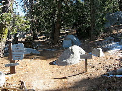
I get to the State Park boundary and see something that tells me I am in a completely different environment than the one I left: snow.

It covers the trail in long sections and while its never treacherous or a big problem it does slow me down because it's hard to get a good pace without good footing.

It's surprising to see so much snow in places because I don't remember a storm coming through.

After hiking a good deal in the snow, it is welcome to find any dry patch along the way.

This is the first water on the trail that I've come to since the drinking fountain down at the bottom, over twenty miles ago. I have to be careful crossing here because I've already slipped on ice twice.

Little Round Valley is a campground below San Jacinto Peak and it makes me feel like I'm almost home. It's 1.6 miles to San Jacinto Peak and 7 miles from the Tram but for some reason it makes me feel like I'm close.

Climbing up to the Peak I am able to look west and see the golden shimmer of the Pacific Ocean.

Heading up to the summit I pass the CCC cabin. I am tempted to stop inside but might not want to leave so I bypass it.

It is a welcome relief to get to the top. I try to grin but only manage a grimace. I'm pretty tired at this point but it's all downhill from here.

There are a couple of shortcuts coming down from the top of San Jacinto but I go down the tried and true route through Wellman's Divide. I didn't want to try any other route because I did not want to tromp through any more snow.

I get to the Long Valley Ranger Station almost exactly twelve hours from when I left Snow Creek, drop off my copy of my permit and head straight for the Tramway Bar.

I didn't just hike thirty miles for nothing.

Monday, August 24, 2009

Fobe's Trail to the PCT

DAY TWO HUNDRED AND THIRTY SIX

One of the toughest things about coming home from a trip is the nagging feeling that you left something behind. Even though I work in a hotel I have left things behind that were never recovered. It's very annoying.

When I was preparing for this last trip I found a couple of things which I believed were lost forever so it is not totally hopeless. Things do sometimes find their way home.

Well, it seems like I am not the only one who leaves things behind. The wife's father, aka Papa, left his fishing gear in the mighty minivan when he unloaded his gear. I don't have any idea why he'd have been so hasty in getting his stuff. It's not like he was in a hurry to get in his house after a week traveling with us or anything.

Wonderful husband that I am volunteered to make the road trip up the hill to bring him his gear back and left the boys with the wife and off I went. It's the kind of sacrifices I have to make sometimes.

I decided to do the Fobe's Ranch Trail to the PCT. I hadn't done this trail yet this year and its three miles round trip distance was about all I'd have time to do today.

I think this decrepit sign is in need of a replacement. I don't know if I need a permit on this trail because I can't read the sign. Oh well.

The trail itself is in pretty good shape as it steadily gains elevation. It's never really steep but it doesn't have any downhill section, thankfully.

Along the way I spot an old water tank that's probably still in use.

There's also a fairly new gate.

And a really new sign telling me to keep it closed.

As I near the PCT I start to get to some larger trees and a bit of shade. Kahlua likes the area so we take a short break. Very short.

At the junction of the two trails there are some nice big boulders.

And while the view is not evident directly from the trail, we hike a little bit and get a view of the Coachella Valley below, sweltering in 100+ degree heat.

In addition to the new gate sign there are also some new trail signs. At least they weren't here when I came by on the PCT a few years ago. If you look real close you can see where someone wrote directions on how to find H2O. Spitler Peak looms in the background.

There's also another little sign directing you to water in case you missed the hand written directions.

The trail is not really tough and is a quick and easy way to access the PCT and get a high view of the Coachella Valley. Despite that someone left this reminder that even an easy trail is tougher than a walk in the park.

Saturday, July 11, 2009

The Buck Stops Here

DAY ONE HUNDRED AND NINETY TWO

Every day the forecast for the desert shows a high of over 110º. Whenever possible I will be going to higher elevations for my hike. Luckily for me today, I was able to.

The closest place I can get to that is out of the heat is the Pacific Crest Trail. The temperature there is almost 90º but compared to home it feels cool to me.

Mercifully, a lot of the trail is in the shade so that helps make it very comfortable. Kahlua doesn't know what it's like to hike in such nice weather. She runs around and tries to catch anything the moves: butterflies, blowing leaves, ants and a baby rabbit. I'm happy when the rabbit gets away.

I hike up the trail a bit and see this clearing has been cleared out a bit. I don't know if it's been logged, if it's being cleared as a fire break or if development is on the way. Whatever is going on, it is a shame that it has to happen within the view of the trail. In my opinion, the trail corridor should be kept as pristine as possible.

There has definitely been some logging going on.

And this road is new.

Here is what is creating this destruction. This little area would make a nice yellow post campsite but I doubt that is what's going on here.

We decide to do a little investigation so we walk up this road to see what's up here.

OK. This sign is persuasive at getting me to turn around. If I ever had some property that I didn't want people to come onto I'd get a sign like this. Explosives and lasers! Adios.

We decide to go back and see if the road we're on takes us back to Hwy. 74. In the meadow, I see this buck grazing.

He's very wary. He takes a couple of bites and looks up. I think he senses Kahlua running up and down the road although I don't think he can see her with all the vegetation. Shortly after this he heads off into the woods.

We continue up this road, through this open gate, putting distance between us and the lasers and explosives.

There's a sign showing the Forest Service boundary. Unfortunately, we are on the wrong side of the fence.

We work our way to a place where we can hop the fence and get back to Highway 74. It'll be an easy mile to get back to the parking area and the Jeep.

The sun is going down just as we reach the parking area.

Kahlua enjoys are well deserved drink. She's not bottle trained but this bottom of a Del Taco cup works very well. For her birthday, though, I think I'll get her a real doggie hiking bowl. She's earned it.