Showing posts with label Palm Canyon. Show all posts

Thursday, December 31, 2009

Palm Canyon Trading Post to Bullseye Rock

DAY THREE HUNDRED AND SIXTY FIVE

Bullseye Rock is a place in the Indian Canyons that holds an interesting place in the history of the Cahuilla Indians. It was known as the You coo hal ya me?, The place of many brains. The story goes that the Indians of Palm Springs had a dispute with the Indians of Seven Palms and a raiding party was formed. The Palm Springs warriors slaughtered their foes and carried their heads back in nets to Bullseye Rock. Here, their heads were rolled down the rock and dashed to bits. It is easy to see how this could have been done. There's a little trough running down the face of Bullseye Rock and a head would probably roll down it quite nicely.

Starting at the Trading Post, the trail to Bullseye Rock has a sign now. Sort of. Bullseye Rock is not listed on any sign but it is in the vicinity of Indian Potrero, an old village site.

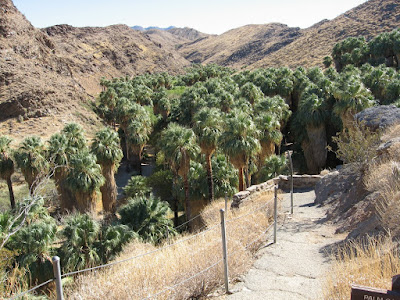
You go through the Palm Canyon Oasis and its over 3000 palms including the Rainbow Palm.

The trail goes straight through the palms and then ascends up out of the canyon and onto the ridge.

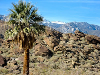
From there, the hike goes overland and offers great views of the San Jacinto Mountains to the west and Santa Rosa Mountain (seen here in the background) to the south.

After about a mile, you come to another sign near Dry Wash. Off to the right there are some non descript looking rocks that are very significant in the history of the Cahuilla people.

This area of rocks was basically the maternity ward for the Indians of this region. The rocks in the foreground that are pock marked are covered with cupules. These little petroglyphs are placed here to represent and significant event, probably a birth or a pregnancy.

There are dozens of them.

Here's a closer look.

After leaving the birthing rocks, I continue on to Indian Potrero. Potrero is a Spanish word meaning meadow or pasture. It is easy to see why this area got its name. This nice little flat is littered with mesquite bushes, a major food source for the Indians.

It doesn't take much looking around before I find a bedrock mortar. This one is filled with water and I place my pole basket near it so you can get an idea of its size.

A little more searching around brings me to this rock shelter. There is a significant amount of pitch on the top of this shelter so it's obvious it was used for a long time.

There are two large bedrock mortars here and a mano. A smaller mortar is just out of view.

A couple more bedrock mortars are nearby.

On the way to Bullseye Rock, I find a couple small pottery sherds.
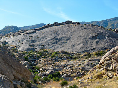
This is Bullseye Rock. If you enlarge the picture and look close you can see the groove that a head would roll nicely down. Beyond the rock is Bullseye Flat and beyond that, Mad Women Spring. I won't be going there today but will save that for another trip. The Canyons are closing early today and I got a late start. Bullseye Flat has more Indian areas of significance and there's an old line shack with provisions at Mad Women Spring. They'll have to wait for another day, another year. I'd love to do a backpack trip here and do some real exploring.

The Cahuilla had names for all kinds of places, streams, rocks, geologic features. I wonder what they would have called this leaning rock?

On my way back I find more pot sherds without really even looking for them.

There are also some more areas where rocks were used as a kitchen.
It has been quite a hike and quite a year. I plan on doing an overview of my favorite hikes and pictures of the year in the coming days.

It has been an incredible experience to hike every day this year. I have discovered places I would have never known existed and now have leads on more places to explore in the future. While I will not be hiking every day in the coming years, I will not be giving up blogging or hiking. What I intend to do is concentrate more on quality instead of quantity. I also want to add video and other multimedia components. Keep coming back and if you have a favorite hike or picture, post a comment or send me an email.

Thanks for your love and support. Have a great 2010.

Hal


Saturday, October 31, 2009

Palm Canyon Trail, Palm Springs Indian Canyons

DAY THREE HUNDRED AND FOUR

Palm Canyon is the jewel of Palm Springs hiking. It is an eighteen mile canyon with unlimited options for adventure. There are numerous palm oases, including the main Palm Canyon oasis with over 3000 palms, streams, year-round springs, Indian trails and ancient village sites. It is an area worthy of a lifetime of exploration. Too bad I only had a couple of hours.

I enjoy hiking so much in the Indian Canyons--although I consider it a bit too expensive to go often--I'd like to live there. I wonder if this place is available?

I park near the Trading Post and head down to the incredible main oasis.

I find these two braves ready to go out and explore but I wonder if they are up to it.

Are you kidding me? We were born ready, they tell me.

Which way should we go?

We head up the main canyon toward the Victor Trail and the canyon is lush with growth. It's the type of place you'd never know was in the desert unless you'd be there.

One reason it's so lush is springs that just bubble right out of the ground.

The water is somewhat warm. It's not a hot spring but a tepid one.

Along the way we use these rocks to make it across the stream. We don't really need them now but they'll be handy in the spring.

I had originally wanted to do a loop hike and come back the Victor Trail but that's not really very exciting for boys. What adventure is there to just hiking on a trail? So, we decide to follow the creek bed up and it's easy since there's really no water in it this time of year.

Along the way Nik picks apart a Cattail and its parts float up into the air. It is reminiscent of snow floating on the wind so Nik dubs the Cattail a "snow wand".

The "snow" floats above us on the wind. Click on the picture and look for the white dots on the photo. That's the "snow".

This is a great adventure for these young braves. They get to climb logs.

Play Atlas trying to hold up the world

And just kick back.

Boys love going through the jungle.

Or maybe not.

They love jumping off rocks.

Or maybe not.

But all in all it was the best adventure these young braves have ever had, at least until the next one. And with all the places to explore in the Palm Canyon area there are sure to be many, many more.

But we can't go until they slide down the rocks just one more time.

Monday, October 26, 2009

Upper Palm Canyon

DAY TWO HUNDRED AND NINETY NINE

Anyone who has been to Palm Springs knows Palm Canyon Drive. It is the main drag in downtown and attracts more tourist traffic than any other street in the desert. Far fewer people are familiar with the canyon that gave that street its name and even fewer know the upper reaches of the canyon.

Visitors to the Indian Canyons, south of Palm Springs, can visit the largest palm oasis in North America for which the canyon was named. There are over three thousand palms and this section of Palm Canyon boasts many hiking opportunities. But this is only a small part of Palm Canyon. Palm Canyon is over eighteen miles long and reaches well into the mountains of the Santa Rosa and San Jacinto National Monument.

To get to the section of Palm Canyon that I explored today, you have to drive about twenty miles up Highway 74 to Ribbonwood and start there.

The Pines to Palms Trail is no misnomer. While there are no pines at the beginning of the trail, there are quite a few along the way.

From up here, at the 4000 foot level, you can see all the way down into the desert.

I think what I'll do today is go down to the canyon bottom, hike to Omstott Canyon and then come back up the ridge route.

The canyon bottom, like most things this time of year in the desert, is bone dry. Of course, that makes travel a little easier.

Along the trail is this gate since the upper reaches of this canyon are used as a grazing area for free range cattle. The Wellman Family has run cattle in this area going back generations.

I find a lot of odds things on my hike but I have no idea how this got way down here. There is no road even remotely close to where I am.

I check my time and determine that I really don't have time to make it down to Omstott Canyon and back before dark. I decide to take this ridge up to met the Ridge Trail instead. Hopefully, it's not too tough.

But first I have to make it through some of the brush down in the canyon. At this point I'm wishing I wore long pants.

From the ridge I am able to look down the canyon and I wish I had just a bit more time. I'll have to come back when I have the whole day. I think that might be sometime in 2015.

This section of the ridge worried my a bit when I was looking up at it but I'm able to go around it on the left. There even appears to be a bit of a trail up this ridge.

Maybe there was a trail here because this branch was sawn by someone. It just didn't break like this, in a perfect line.

Kahlua the Tracker also thinks there's a trail here somewhere.

There's no doubt about this trail.

We head out the cattle gate up here and wish we'd had more time to explore. There is a lot of terrain and history in this area and very few people go here other than just passing through.

It's so beautiful here so I'd like to come back sometime when we can stay a while.