DAY THREE HUNDRED AND FORTY EIGHT
I went today to a place in the Santa Rosa Mountains south of Martinez Canyon that I'd never been to. I figured with a name like Sheep Canyon there was a good chance there might be Bighorn there or something else interesting.

To get to where I'd start hiking I'd have to drive through some orchards and a bit of a garbage dump. It's obvious that someone's been here before.

I head up the canyon looking to see if there might be a trail leaving the wash and heading up toward the hills.

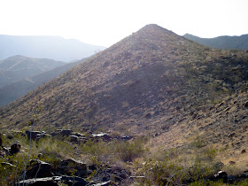
I get past the mud cliffs and find an area to leave the wash and look around. The terrain is not easy to traverse. It's very rocky.

If you don't watch your every step there's a distinct possibility of falling and getting hurt. I get a bit injured and come inches from planting my face on a big boulder. Fortunately, my injuries are minor and I can continue on.

In the midst of a big boulder field, we come upon this nice barren flat.

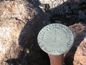
It's readily obvious that this area has been visited before.

There's a benchmark from the General Land Office, a government agency that ceased to exist over 60 years ago. The date on it says 1917 and there's a good possibility it was put here then.

Looking south I see what I came here to find, a trail.

I'm sure there are dozens of trails in these mountains that no one knows about and I intend on finding them all.

The trail heads down to this wash but this is not the canyon I came here to explore today. It looks like there's possibly a palm oasis up there but that'll have to wait for another day.

We head over to Sheep Canyon to give it a little look.

The trail drops right into the canyon and I quickly see why.

The canyon is full of mesquite, a food staple of the Cahuilla Indians.

A bit further up the canyon is this weird looking rock area. It looks almost like concrete that has been weathered. There is lots of indications that Indians lived here.

There are several bedrock mortars all over the top of the rocks.

Some are over a foot deep.

On the south side of the wash is a little area that was obviously a campsite. There are a few fire rings and numerous mesquite bushes all around.

A few trails are up here as well.

It is obvious that someone's spent some time up here since the Indians moved on. I'd like to spend more time looking around but I also want to head up the canyon bit further and see if I can find another trail. I will be back, though.

The canyon has some very interesting geology.

More importantly, both to the wildlife in the area and the Indians back in the day, there's water. The water is flowing very well so there's a good chance that this is spring fed.

There are many sheep droppings near the water and it's evident that this must be a good place to spot either a sheep or other wildlife. At least, some biologists think so.

On the way back to the Jeep I make one more stop at the "concrete slab" to see how many more bedrock mortars I can find.

I count fourteen but there's a possibility there are more since there's some sand from the recent rains. When I come back--and I'm definitely coming back soon--I'm going to bring a little trowel to move some sand around and plan on spending more time. There's a great campsite so I might even plan a backpacking trip. This is one of my new favorite places.
No comments:
Post a Comment